
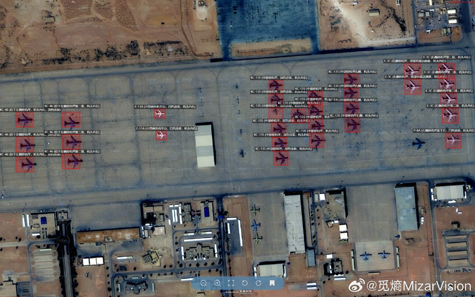
Chinese firm, MizarVision, posted detailed satellite imagery of U.S. forces in the Middle East
X Post
Select Committee on China
A Chinese firm, MizarVision, posted detailed satellite imagery of U.S. forces in the Middle East while not disclosing its data sources. @ChinaSelect analysis found @AirbusSpace satellites had multiple daily windows, up to 10 hours, where they could have captured imagery of U.S. troop positions before the Iran conflict. That imagery later appeared online via a China-based AI company. "These documented facts present a troubling scenario: 1. A Chinese firm with undisclosed satellite sourcing published precise, annotated imagery of U.S. military assets at a specific base. 2. That imagery identified the exact aircraft types that were subsequently destroyed in a precise Iranian strike. 3. A technical analysis suggests Airbus Space satellites were the most plausible sources for that imagery,” concludes Chairman @RepMoolenaar. https://chinaselectcommittee.house.gov/media/press-releases/airbus-space-likely-provided-satellite-imagery-of-us-military-assets-to-china-before-operation-epic-fury
Airbus Space Likely Provided Satellite Imagery of U.S. Military Assets to China Before Operation Epic Fury (link)
Select Committee on China Chairman John Moolenaar has sent a letter to Secretary of War Pete Hegseth concerning the operations of Airbus Space due to its role in likely providing satellite imagery of U.S. military assets to MizarVision, a Chinese entity, days before the commencement of Operation Epic Fury.
"While commercial satellite imagery may serve public interest purposes in some cases, unconstrained imagery provision exposing U.S. forces to heightened risk crosses a dangerous threshold," Moolenaar begins in the letter. "Near-real-time publication of precise, annotated imagery identifying the exact type, number, and location of specific high-value military assets at an active forward operating base—while those assets are actively engaged in combat operations—is targeting data for enemy forces."
"The Select Committee’s independent analysis tracked the positions and flight paths of four Airbus satellites over the area of interest across a 48-hour window. For each moment in that window, three conditions had to be met for collection to be considered feasible: (1) the satellite had to be in the right position to see the area, (2) its camera had to be capable of pointing in the right direction, and (3) there had to be enough daylight to take an optical photograph. Moments that passed all three tests were flagged as plausible collection opportunities," he continues.
"These documented facts present a troubling scenario: 1. A Chinese firm with undisclosed satellite sourcing published precise, annotated imagery of U.S. military assets at a specific base. 2. That imagery identified the exact aircraft types that were subsequently destroyed in a precise Iranian strike. 3. A technical analysis suggests Airbus Space satellites were the most plausible sources for that imagery,” concludes Moolenaar.
The Select Committee has previously investigated aerospace companies' ties to China. In December, Moolenaar wrote a letter to Hegseth concerning Airbus's role in advancing China's military-civil fusion.
Read the new letter regarding Airbus Space here.